


FlightIntel
توضیحات FlightIntel
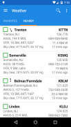
فقط فرودگاه های ایالات متحده
FlightIntel طوری طراحی شده است که در تمام مراحل پرواز منبعی برای خلبان باشد. این اطلاعات دقیق در مورد بیش از 5500 فرودگاه عمومی ایالات متحده ارائه می دهد. داده های AF/D در تلفن شما دانلود می شود و برای استفاده آفلاین در دسترس است.
لطفا امتیازات و نظرات خود را برای نشان دادن حمایت و قدردانی خود بگذارید. متشکرم.
امکانات:
=========
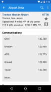
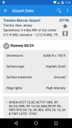
* اطلاعات کامل در مورد بیش از 5500 فرودگاه عمومی ایالات متحده
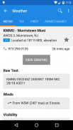
* Wx دقیق برای تمام برنامه ریزی پرواز شما
* دسترسی رایگان به d-TPP از جمله نمودارهای فرودگاه و d-CS
* به روز رسانی رایگان داده طبق چرخه داده FAA
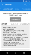
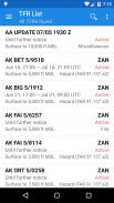
* TFR ها، Notams و D-ATIS
* E6B
* Scratchpad
* کتابخانه گسترده ای از کتاب های مرتبط با هوانوردی و مجلات PDF
* فقط فرودگاه های ایالات متحده
* بدون تبلیغات و بدون جمع آوری اطلاعات شخصی
مجوزها
===========
* موقعیت مکانی خوب (GPS) - برای تعیین مکان فعلی برای نشان دادن فرودگاه های نزدیک / ایستگاه های wx.
* دسترسی کامل به اینترنت - برای دانلود فایل های داده، آب و هوا، NOTAMS، AeroNav PDF و غیره.
* اصلاح/حذف محتویات کارت SD - برای ذخیره فایل های داده، ذخیره اطلاعات آب و هوا و فایل های PDF.
* مشاهده وضعیت شبکه - برای بررسی اینکه آیا به اینترنت متصل است و برای تعیین اینکه آیا برای دانلود به WIFI متصل است یا خیر.
تست بتا
==========
میتوانید برای آزمایش نسخههای بتا در صورت موجود بودن در اینجا شرکت کنید:
https://play.google.com/apps/testing/com.nadmm.airports
در توییتر دنبال کنید: @FlightIntel
گروه های کاربر: https://groups.google.com/forum/?hl=en&fromgroups#!forum/flightintel-users
ردیاب مشکلات: https://github.com/nhasan/FlightIntel/issues
منبع: https://github.com/nhasan/FlightIntel
*****************************************
مهم: اگر FC را تجربه میکنید، لطفاً مطمئن شوید که آخرین نسخه را اجرا میکنید و آخرین بهروزرسانی داده را نصب کردهاید.
*****************************************
FlightIntel - نسخه 6.30.7
(20-10-2023)FlightIntel - اطلاعات APK
نسخه APK: 6.30.7حزمة: com.nadmm.airportsآخرین نسخه FlightIntel
سایر نسخهها


اپلیکیشنها در دسته مشابه

شاید دوست داشته باشید...


